River Ridge night lights from space
Night Light of River Ridge (Louisiana) from space (United States) Src. Average luminocity for 10x10km area is 93.108% and for 50x50km: 40.1216%.
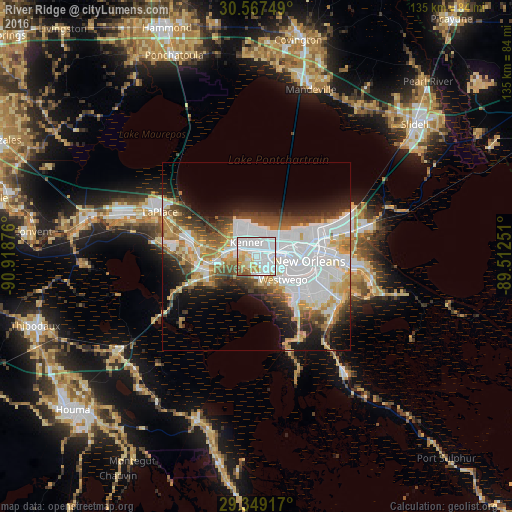
Analysis of River Ridge night lights 2016
Square area 10x10 km:
 53.6%
53.6%90-99
21.4%80-89
10.23%70-79
7.39%60-69
4.17%50-59
3.03%40-49
0.19%30-39
0%20-29
0%10-19
0%0-9
0%Square area 50x50 km:
14.9%90-99
7.17%80-89
4.88%70-79
4.07%60-69
4.23%50-59
2.94%40-49
4.7%30-39
4.31%20-29
5.32%10-19
9.3%0-9
38.19%Clear (daylight) street map image can be seen on geolist.org.
Map coordinates:
30° 34' 3" North, 90° 55' 7.5" West
29° 57' 36.7" North, 90° 12' 56.3" West
29° 20' 57" North, 89° 30' 45" West
Some cities around River Ridge sort by population:
• Metairie Terrace
5.4 km =3.4 mi,  67°
67°
• Metairie
6.6 km =4.1 mi, 66°
• Kenner
4.5 km =2.8 mi,  326°
326°
• Jefferson
6.1 km =3.8 mi,  83°
83°
• Waggaman
4.7 km =2.9 mi,  174°
174°
• Harahan
2.5 km =1.6 mi,  151°
151°
• Westwego
9.3 km =5.8 mi,  130°
130°
• Bridge City
5.3 km =3.3 mi,  124°
124°
4338818 (p: 13,494)
Sources (retrieved 2019-11-25):
» Earth at Night: Flat Maps 2012, 2016