Abingdon night lights from space
Night Light of Abingdon (Virginia) from space (United States) Src. Average luminocity for 10x10km area is 39.4176% and for 50x50km: 9.9522%.
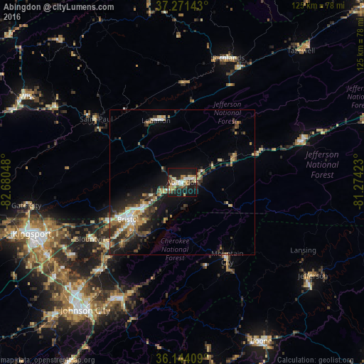
Analysis of Abingdon night lights 2016
Square area 10x10 km:
 4.4%
4.4%90-99
5.68%80-89
8.06%70-79
3.85%60-69
6.59%50-59
4.76%40-49
5.13%30-39
5.86%20-29
7.14%10-19
44.51%0-9
4.03%Square area 50x50 km:
1.07%90-99
1.05%80-89
1.47%70-79
1.21%60-69
1.44%50-59
1.25%40-49
1.66%30-39
2.33%20-29
2.94%10-19
7.08%0-9
78.49%Clear (daylight) street map image can be seen on geolist.org.
Map coordinates:
37° 16' 17.1" North, 82° 40' 49.7" West
36° 42' 35.4" North, 81° 58' 38.5" West
36° 8' 38.7" North, 81° 16' 27.2" West
Some cities around Abingdon sort by population:
• Kingsport
55.2 km =34.3 mi,  251°
251°
• Bristol
22.8 km =14.2 mi,  235°
235°
• Bristol
22.7 km =14.1 mi, 236°
• Elizabethton
45.2 km =28.1 mi,  207°
207°
• Bloomingdale
47.7 km =29.6 mi, 253°
• Colonial Heights
53.2 km =33.1 mi, 241°
• Marion
43.5 km =27 mi,  71°
71°
• Richlands
45.6 km =28.3 mi,  20°
20°
4743815 (p: 8,119)
Sources (retrieved 2019-11-25):
» Earth at Night: Flat Maps 2012, 2016