Pleasantville night lights from space
Night Light of Pleasantville (New Jersey) from space (United States) Src. Average luminocity for 10x10km area is 71.3282% and for 50x50km: 16.5738%.
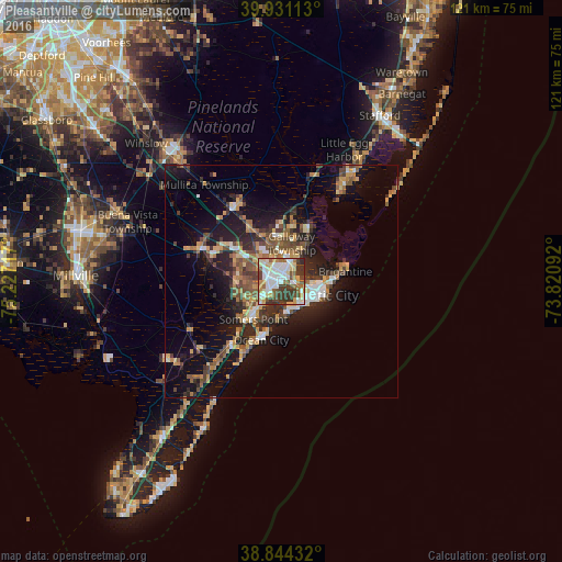

Analysis of Pleasantville night lights 2016
Square area 10x10 km:
 17.18%
90-99
19.9%80-89
10.71%70-79
8.33%60-69
5.44%50-59
10.37%40-49
9.52%30-39
16.67%20-29
1.87%10-19
0%0-9
0%Square area 50x50 km:
1.84%90-99
2%80-89
2.18%70-79
2.19%60-69
2.26%50-59
2.89%40-49
3.1%30-39
3.1%20-29
4.59%10-19
11.72%0-9
64.13%Clear (daylight) street map image can be seen on geolist.org.
Map coordinates:
39° 55' 52.1" North, 75° 13' 37.8" West
39° 23' 23.4" North, 74° 31' 26.5" West
38° 50' 39.6" North, 73° 49' 15.3" West
Some cities around Pleasantville sort by population:
• Atlantic City
9.1 km =5.7 mi,  108°
108°
• Somers Point
10.1 km =6.3 mi,  217°
217°
• Ventnor City
6.8 km =4.2 mi,  143°
143°
• Northfield
3.1 km =1.9 mi,  226°
226°
• Absecon
4.9 km =3 mi,  29°
29°
• Pomona
10.8 km =6.7 mi,  335°
335°
• Linwood
7.1 km =4.4 mi, 218°
• Margate City
7.1 km =4.4 mi,  165°
165°
4503646 (p: 20,755)
Sources (retrieved 2019-11-25):
» Earth at Night: Flat Maps 2012, 2016