Ventnor City night lights from space
Night Light of Ventnor City (New Jersey) from space (United States) Src. Average luminocity for 10x10km area is 48.9592% and for 50x50km: 15.5044%.
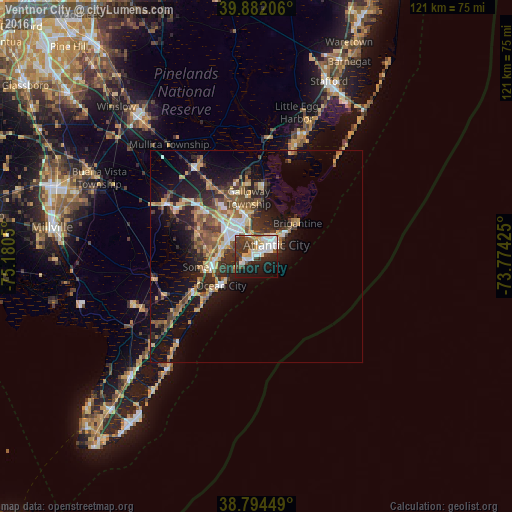
Analysis of Ventnor City night lights 2016
Square area 10x10 km:
 13.1%
13.1%90-99
12.76%80-89
3.23%70-79
3.57%60-69
2.04%50-59
4.08%40-49
7.14%30-39
14.63%20-29
11.22%10-19
21.77%0-9
6.46%Square area 50x50 km:
1.82%90-99
1.94%80-89
2.16%70-79
1.95%60-69
2.08%50-59
2.68%40-49
2.82%30-39
2.93%20-29
4.45%10-19
11.36%0-9
65.83%Clear (daylight) street map image can be seen on geolist.org.
Map coordinates:
39° 52' 55.4" North, 75° 10' 49.8" West
39° 20' 25.4" North, 74° 28' 38.5" West
38° 47' 40.2" North, 73° 46' 27.3" West
Some cities around Ventnor City sort by population:
• Atlantic City
5.4 km =3.4 mi,  60°
60°
• Pleasantville
6.8 km =4.2 mi,  323°
323°
• Ocean City
10.9 km =6.8 mi,  230°
230°
• Somers Point
10.4 km =6.5 mi,  255°
255°
• Northfield
7.1 km =4.4 mi,  298°
298°
• Absecon
9.9 km =6.2 mi,  350°
350°
• Linwood
8.4 km =5.2 mi,  269°
269°
• Margate City
2.6 km =1.6 mi,  238°
238°
4504598 (p: 10,486)
Sources (retrieved 2019-11-25):
» Earth at Night: Flat Maps 2012, 2016