Philadelphia night lights from space
Night Light of Philadelphia (Mississippi) from space (United States) Src. Average luminocity for 10x10km area is 39.3147% and for 50x50km: 4.9322%.
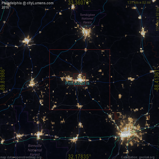
Analysis of Philadelphia night lights 2016
Square area 10x10 km:
 4.72%
4.72%90-99
4.37%80-89
7.17%70-79
3.5%60-69
8.04%50-59
4.37%40-49
5.94%30-39
7.52%20-29
11.01%10-19
41.61%0-9
1.75%Square area 50x50 km:
0.27%90-99
0.27%80-89
0.68%70-79
0.46%60-69
0.93%50-59
0.67%40-49
0.98%30-39
1.45%20-29
1.32%10-19
4.56%0-9
88.4%Clear (daylight) street map image can be seen on geolist.org.
Map coordinates:
33° 21' 38.7" North, 89° 49' 11.5" West
32° 46' 17.5" North, 89° 7' 0.2" West
32° 10' 42.1" North, 88° 24' 49" West
Some cities around Philadelphia sort by population:
• Meridian
59.6 km =37 mi,  139°
139°
• Madison
99.7 km =62 mi,  249°
249°
• Starkville
80.4 km =50 mi,  20°
20°
• Brandon
98.5 km =61.2 mi,  235°
235°
• Canton
87.9 km =54.6 mi,  258°
258°
• Kosciusko
54.4 km =33.8 mi,  305°
305°
• Louisville
39.6 km =24.6 mi,  8°
8°
• Forest
56.3 km =35 mi,  216°
216°
4440906 (p: 7,391)
Sources (retrieved 2019-11-25):
» Earth at Night: Flat Maps 2012, 2016