Forest night lights from space
Night Light of Forest (Mississippi) from space (United States) Src. Average luminocity for 10x10km area is 29.9799% and for 50x50km: 4.1852%.
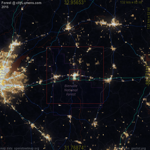
Analysis of Forest night lights 2016
Square area 10x10 km:
 4.03%
4.03%90-99
3.11%80-89
4.95%70-79
3.85%60-69
4.95%50-59
4.58%40-49
4.95%30-39
1.83%20-29
3.11%10-19
39.19%0-9
25.46%Square area 50x50 km:
0.2%90-99
0.2%80-89
0.6%70-79
0.4%60-69
0.54%50-59
0.61%40-49
0.84%30-39
1.54%20-29
1.07%10-19
2.56%0-9
91.44%Clear (daylight) street map image can be seen on geolist.org.
Map coordinates:
32° 57' 23.5" North, 90° 10' 38.5" West
32° 21' 52.5" North, 89° 28' 27.2" West
31° 46' 7.5" North, 88° 46' 16" West
Some cities around Forest sort by population:
• Pearl
62.6 km =38.9 mi,  260°
260°
• Madison
61.1 km =38 mi,  280°
280°
• Ridgeland
62.2 km =38.6 mi, 276°
• Brandon
49.1 km =30.5 mi, 258°
• Canton
59.5 km =37 mi,  297°
297°
• Flowood
62.7 km =39 mi, 264°
• Philadelphia
56.3 km =35 mi,  36°
36°
• Richland
65.8 km =40.9 mi, 257°
4426884 (p: 5,695)
Sources (retrieved 2019-11-25):
» Earth at Night: Flat Maps 2012, 2016