Phenix City night lights from space
Night Light of Phenix City (Alabama) from space (United States) Src. Average luminocity for 10x10km area is 90.141% and for 50x50km: 25.2274%.
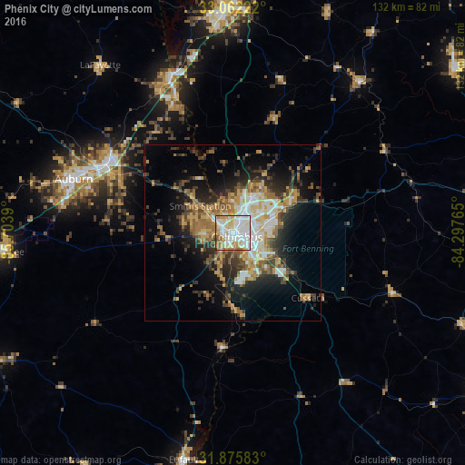

Analysis of Phenix City night lights 2016
Square area 10x10 km:
 35.53%
90-99
32.42%80-89
8.24%70-79
12.27%60-69
7.69%50-59
2.75%40-49
0.73%30-39
0.37%20-29
0%10-19
0%0-9
0%Square area 50x50 km:
4.15%90-99
3.96%80-89
3.47%70-79
3.75%60-69
4.09%50-59
2.96%40-49
3.26%30-39
4.85%20-29
5.98%10-19
10.42%0-9
53.11%Clear (daylight) street map image can be seen on geolist.org.
Map coordinates:
33° 3' 44" North, 85° 42' 14" West
32° 28' 15.5" North, 85° 0' 2.8" West
31° 52' 33" North, 84° 17' 51.5" West
Some cities around Phenix City sort by population:
• Columbus
1.7 km =1.1 mi,  132°
132°
• Auburn
47.6 km =29.6 mi,  288°
288°
• LaGrange
63.3 km =39.3 mi,  357°
357°
• Opelika
40.3 km =25 mi,  298°
298°
• Cusseta
28.2 km =17.5 mi, 130°
• Valley
42.1 km =26.2 mi,  336°
336°
• Lanett
47.7 km =29.6 mi, 338°
• Smiths Station
12 km =7.5 mi,  309°
309°
4082866 (p: 37,570)
Sources (retrieved 2019-11-25):
» Earth at Night: Flat Maps 2012, 2016