Cusseta night lights from space
Night Light of Cusseta (Georgia) from space (United States) Src. Average luminocity for 10x10km area is 8.7253% and for 50x50km: 13.6321%.
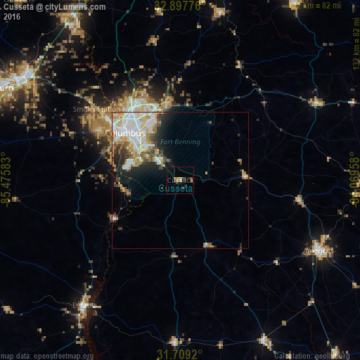
Analysis of Cusseta night lights 2016
Square area 10x10 km:
 0%
0%90-99
0%80-89
1.1%70-79
2.2%60-69
2.38%50-59
0.92%40-49
0.92%30-39
3.48%20-29
1.1%10-19
0.92%0-9
87%Square area 50x50 km:
3.35%90-99
3.02%80-89
1.75%70-79
1.92%60-69
1.44%50-59
1.17%40-49
1.39%30-39
1.88%20-29
2.34%10-19
3.81%0-9
77.94%Clear (daylight) street map image can be seen on geolist.org.
Map coordinates:
32° 53' 51.9" North, 85° 28' 33" West
32° 18' 19.5" North, 84° 46' 21.7" West
31° 42' 33.1" North, 84° 4' 10.5" West
Some cities around Cusseta sort by population:
• Columbus
26.6 km =16.5 mi,  310°
310°
• Phenix City
28.2 km =17.5 mi, 310°
• Opelika
68.2 km =42.4 mi,  303°
303°
• Americus
57 km =35.4 mi,  117°
117°
• Eufaula
57.9 km =36 mi,  217°
217°
• Valley
68.6 km =42.6 mi,  326°
326°
• Lanett
73.9 km =45.9 mi, 327°
• Smiths Station
40.2 km =25 mi, 310°
4190434 (p: 11,267)
Sources (retrieved 2019-11-25):
» Earth at Night: Flat Maps 2012, 2016