Pearl River night lights from space
Night Light of Pearl River (New York) from space (United States) Src. Average luminocity for 10x10km area is 72.4805% and for 50x50km: 57.8281%.
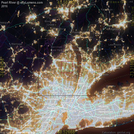
Analysis of Pearl River night lights 2016
Square area 10x10 km:
 9.09%
9.09%90-99
12.34%80-89
7.63%70-79
10.88%60-69
44.81%50-59
13.8%40-49
1.46%30-39
0%20-29
0%10-19
0%0-9
0%Square area 50x50 km:
14.92%90-99
11.7%80-89
6.96%70-79
9.5%60-69
12.67%50-59
7.12%40-49
4.34%30-39
4.48%20-29
6.83%10-19
7.68%0-9
13.82%Clear (daylight) street map image can be seen on geolist.org.
Map coordinates:
41° 35' 13.3" North, 74° 43' 29.8" West
41° 3' 32.4" North, 74° 1' 18.5" West
40° 31' 36" North, 73° 19' 7.3" West
Some cities around Pearl River sort by population:
• Spring Valley
6.3 km =3.9 mi,  343°
343°
• Nanuet
3.4 km =2.1 mi,  11°
11°
• Park Ridge
2.9 km =1.8 mi,  213°
213°
• Montvale
1.4 km =0.9 mi,  183°
183°
• Chestnut Ridge
4 km =2.5 mi,  314°
314°
• Old Tappan
6 km =3.7 mi,  154°
154°
• Woodcliff Lake
5.4 km =3.4 mi,  223°
223°
• Blauvelt
5.4 km =3.4 mi,  84°
84°
5130780 (p: 15,876)
Sources (retrieved 2019-11-25):
» Earth at Night: Flat Maps 2012, 2016