Park Ridge night lights from space
Night Light of Park Ridge (New Jersey) from space (United States) Src. Average luminocity for 10x10km area is 68.3537% and for 50x50km: 60.9334%.
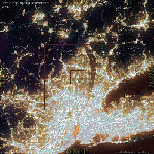
Analysis of Park Ridge night lights 2016
Square area 10x10 km:
 5.1%
5.1%90-99
7.48%80-89
4.42%70-79
10.37%60-69
55.61%50-59
15.48%40-49
1.53%30-39
0%20-29
0%10-19
0%0-9
0%Square area 50x50 km:
16.93%90-99
13.14%80-89
7.1%70-79
9.7%60-69
12.4%50-59
7.25%40-49
4.7%30-39
3.99%20-29
5.8%10-19
6.21%0-9
12.79%Clear (daylight) street map image can be seen on geolist.org.
Map coordinates:
41° 33' 56.9" North, 74° 44' 37.8" West
41° 2' 15.4" North, 74° 2' 26.5" West
40° 30' 18.4" North, 73° 20' 15.3" West
Some cities around Park Ridge sort by population:
• Pearl River
2.9 km =1.8 mi,  33°
33°
• Westwood
5.2 km =3.2 mi,  172°
172°
• Hillsdale
3.9 km =2.4 mi,  179°
179°
• River Vale
5.3 km =3.3 mi,  152°
152°
• Montvale
1.8 km =1.1 mi,  55°
55°
• Chestnut Ridge
5.3 km =3.3 mi,  346°
346°
• Old Tappan
5.1 km =3.2 mi,  125°
125°
• Woodcliff Lake
2.7 km =1.7 mi,  233°
233°
5102400 (p: 8,919)
Sources (retrieved 2019-11-25):
» Earth at Night: Flat Maps 2012, 2016