Chestnut Ridge night lights from space
Night Light of Chestnut Ridge (New York) from space (United States) Src. Average luminocity for 10x10km area is 76.0471% and for 50x50km: 53.2382%.
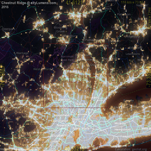
Analysis of Chestnut Ridge night lights 2016
Square area 10x10 km:
 15.75%
90-99
14.77%80-89
7.95%70-79
8.28%60-69
44.32%50-59
8.93%40-49
0%30-39
0%20-29
0%10-19
0%0-9
0%Square area 50x50 km:
11.97%90-99
10.42%80-89
6.41%70-79
9.43%60-69
12.24%50-59
7.39%40-49
4.84%30-39
4.12%20-29
6.54%10-19
8.2%0-9
18.43%Clear (daylight) street map image can be seen on geolist.org.
Map coordinates:
41° 36' 43.6" North, 74° 45' 31.8" West
41° 5' 3.3" North, 74° 3' 20.5" West
40° 33' 7.7" North, 73° 21' 9.3" West
Some cities around Chestnut Ridge sort by population:
• Spring Valley
3.4 km =2.1 mi,  17°
17°
• Monsey
3.2 km =2 mi,  340°
340°
• Nanuet
3.6 km =2.2 mi,  82°
82°
• Pearl River
4 km =2.5 mi,  134°
134°
• Montvale
5 km =3.1 mi,  146°
146°
• Upper Saddle River
4.6 km =2.9 mi,  231°
231°
• Hillcrest
5 km =3.1 mi,  14°
14°
• Kaser
4.2 km =2.6 mi,  346°
346°
5112493 (p: 8,158)
Sources (retrieved 2019-11-25):
» Earth at Night: Flat Maps 2012, 2016