Ozark night lights from space
Night Light of Ozark (Alabama) from space (United States) Src. Average luminocity for 10x10km area is 32.4248% and for 50x50km: 11.3064%.
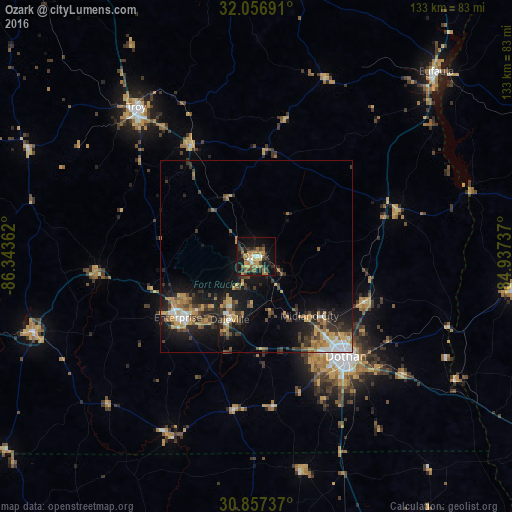
Analysis of Ozark night lights 2016
Square area 10x10 km:
 1.75%
1.75%90-99
2.45%80-89
3.67%70-79
8.57%60-69
7.87%50-59
4.37%40-49
4.9%30-39
5.59%20-29
7.52%10-19
31.64%0-9
21.68%Square area 50x50 km:
1.1%90-99
1.05%80-89
1.06%70-79
2.16%60-69
2.31%50-59
1.08%40-49
1.82%30-39
2.58%20-29
3.3%10-19
8.93%0-9
74.61%Clear (daylight) street map image can be seen on geolist.org.
Map coordinates:
32° 3' 24.9" North, 86° 20' 37" West
31° 27' 32.6" North, 85° 38' 25.8" West
30° 51' 26.5" North, 84° 56' 14.5" West
Some cities around Ozark sort by population:
• Dothan
35.4 km =22 mi,  137°
137°
• Enterprise
25.9 km =16.1 mi,  231°
231°
• Troy
49.8 km =30.9 mi,  321°
321°
• Eufaula
67.1 km =41.7 mi,  44°
44°
• Marianna
85.7 km =53.3 mi,  152°
152°
• Andalusia
81.7 km =50.8 mi,  258°
258°
• Opp
61.6 km =38.3 mi,  251°
251°
• Daleville
17.9 km =11.1 mi,  202°
202°
4081936 (p: 14,719)
Sources (retrieved 2019-11-25):
» Earth at Night: Flat Maps 2012, 2016