Opp night lights from space
Night Light of Opp (Alabama) from space (United States) Src. Average luminocity for 10x10km area is 23.2343% and for 50x50km: 3.702%.
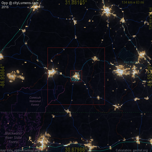
Analysis of Opp night lights 2016
Square area 10x10 km:
 0.87%
0.87%90-99
1.22%80-89
2.62%70-79
9.27%60-69
4.72%50-59
1.57%40-49
1.92%30-39
3.67%20-29
3.85%10-19
15.38%0-9
54.9%Square area 50x50 km:
0.25%90-99
0.25%80-89
0.39%70-79
0.93%60-69
0.76%50-59
0.32%40-49
0.48%30-39
0.83%20-29
0.63%10-19
2.4%0-9
92.75%Clear (daylight) street map image can be seen on geolist.org.
Map coordinates:
31° 52' 53.9" North, 86° 57' 31.1" West
31° 16' 57.6" North, 86° 15' 19.8" West
30° 40' 47.5" North, 85° 33' 8.6" West
Some cities around Opp sort by population:
• Enterprise
38.2 km =23.7 mi,  84°
84°
• Crestview
65.2 km =40.5 mi,  207°
207°
• Troy
64.5 km =40.1 mi,  24°
24°
• Ozark
61.6 km =38.3 mi,  71°
71°
• Andalusia
21.7 km =13.5 mi,  277°
277°
• Greenville
69.8 km =43.4 mi,  330°
330°
• DeFuniak Springs
63.9 km =39.7 mi,  167°
167°
• Daleville
51.6 km =32.1 mi,  86°
86°
4081683 (p: 6,658)
Sources (retrieved 2019-11-25):
» Earth at Night: Flat Maps 2012, 2016