Otsego night lights from space
Night Light of Otsego (Minnesota) from space (United States) Src. Average luminocity for 10x10km area is 38.0545% and for 50x50km: 20.4102%.
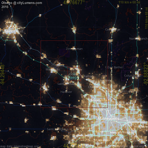
Analysis of Otsego night lights 2016
Square area 10x10 km:
 5%
5%90-99
4.24%80-89
4.7%70-79
5%60-69
3.48%50-59
3.03%40-49
7.58%30-39
10.61%20-29
23.33%10-19
28.18%0-9
4.85%Square area 50x50 km:
3.57%90-99
3.63%80-89
2.38%70-79
2.61%60-69
2.89%50-59
2.98%40-49
2.74%30-39
2.8%20-29
4.35%10-19
10.23%0-9
61.83%Clear (daylight) street map image can be seen on geolist.org.
Map coordinates:
45° 46' 0.4" North, 94° 17' 40.1" West
45° 16' 26.9" North, 93° 35' 28.9" West
44° 46' 37.8" North, 92° 53' 17.6" West
Some cities around Otsego sort by population:
• Ramsey
11.2 km =7 mi,  97°
97°
• Elk River
3.8 km =2.4 mi,  29°
29°
• Saint Michael
9.2 km =5.7 mi,  218°
218°
• Monticello
16.2 km =10.1 mi,  282°
282°
• Rogers
9.9 km =6.2 mi,  162°
162°
• Big Lake
13.7 km =8.5 mi,  298°
298°
• Albertville
6.4 km =4 mi,  230°
230°
• Dayton
6.9 km =4.3 mi,  119°
119°
5040477 (p: 15,551)
Sources (retrieved 2019-11-25):
» Earth at Night: Flat Maps 2012, 2016