Saint Michael night lights from space
Night Light of Saint Michael (Minnesota) from space (United States) Src. Average luminocity for 10x10km area is 26.7621% and for 50x50km: 20.4698%.
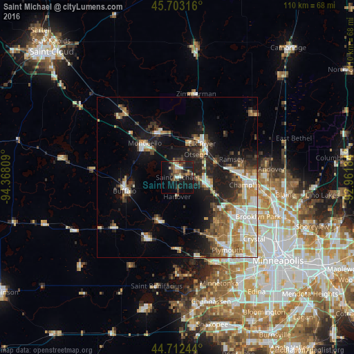
Analysis of Saint Michael night lights 2016
Square area 10x10 km:
 3.18%
3.18%90-99
3.18%80-89
1.97%70-79
2.42%60-69
2.88%50-59
6.52%40-49
7.12%30-39
4.24%20-29
2.58%10-19
32.88%0-9
33.03%Square area 50x50 km:
3.49%90-99
3.68%80-89
2.44%70-79
2.2%60-69
3.07%50-59
3.07%40-49
2.6%30-39
2.7%20-29
4.59%10-19
10.56%0-9
61.6%Clear (daylight) street map image can be seen on geolist.org.
Map coordinates:
45° 42' 11.4" North, 94° 22' 5.1" West
45° 12' 35.9" North, 93° 39' 53.9" West
44° 42' 44.8" North, 92° 57' 42.6" West
Some cities around Saint Michael sort by population:
• Elk River
12.9 km =8 mi,  36°
36°
• Otsego
9.2 km =5.7 mi, 38°
• Monticello
14.7 km =9.1 mi,  316°
316°
• Rogers
9.1 km =5.7 mi,  104°
104°
• Big Lake
15 km =9.3 mi,  335°
335°
• Albertville
3.2 km =2 mi,  14°
14°
• Corcoran
15.7 km =9.8 mi,  144°
144°
• Dayton
12.3 km =7.6 mi,  72°
72°
5045258 (p: 16,399)
Sources (retrieved 2019-11-25):
» Earth at Night: Flat Maps 2012, 2016