Old Greenwich night lights from space
Night Light of Old Greenwich (Connecticut) from space (United States) Src. Average luminocity for 10x10km area is 44.4949% and for 50x50km: 43.588%.
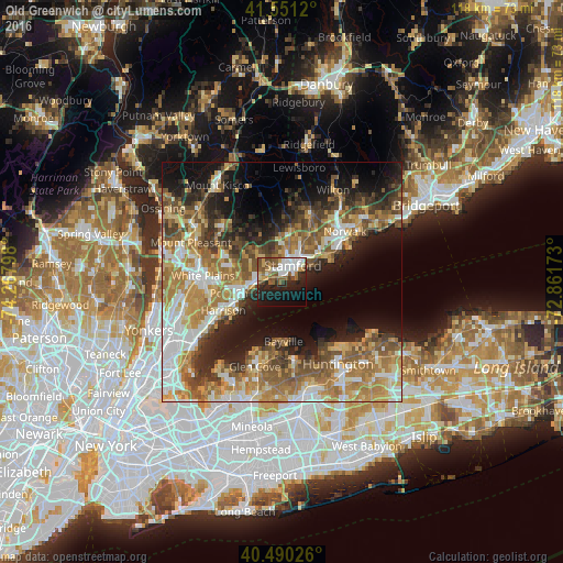
Analysis of Old Greenwich night lights 2016
Square area 10x10 km:
 10.03%
90-99
9.18%80-89
3.23%70-79
3.74%60-69
4.76%50-59
10.37%40-49
6.12%30-39
3.57%20-29
14.29%10-19
22.28%0-9
12.41%Square area 50x50 km:
7.08%90-99
6.8%80-89
5.52%70-79
7.86%60-69
9.28%50-59
7.98%40-49
6.14%30-39
5.22%20-29
8.09%10-19
13.43%0-9
22.59%Clear (daylight) street map image can be seen on geolist.org.
Map coordinates:
41° 33' 4.3" North, 74° 16' 4.7" West
41° 1' 22.3" North, 73° 33' 53.5" West
40° 29' 24.9" North, 72° 51' 42.2" West
Some cities around Old Greenwich sort by population:
• Stamford
4 km =2.5 mi,  32°
32°
• Port Chester
8.8 km =5.5 mi,  254°
254°
• Darien
10.1 km =6.3 mi,  52°
52°
• Rye
11 km =6.8 mi,  244°
244°
• Greenwich
5.4 km =3.4 mi,  274°
274°
• Rye Brook
10 km =6.2 mi, 267°
• Riverside
1.6 km =1 mi,  317°
317°
• Cos Cob
3.1 km =1.9 mi,  291°
291°
4839983 (p: 6,611)
Sources (retrieved 2019-11-25):
» Earth at Night: Flat Maps 2012, 2016