Oasis night lights from space
Night Light of Oasis (California) from space (United States) Src. Average luminocity for 10x10km area is 1.715% and for 50x50km: 4.05%.
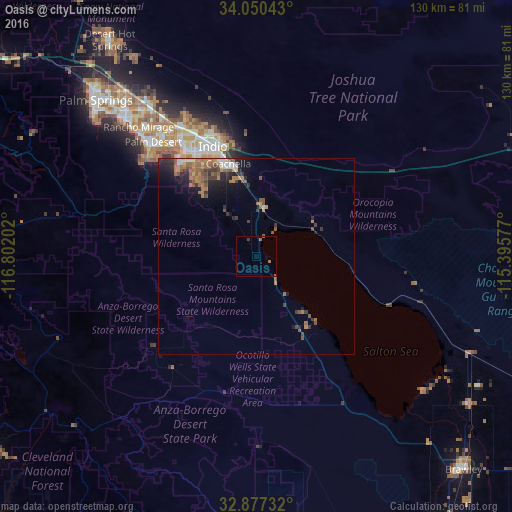
Analysis of Oasis night lights 2016
Square area 10x10 km:
 0%
0%90-99
0%80-89
0%70-79
0%60-69
1.4%50-59
0.52%40-49
0%30-39
0.7%20-29
0%10-19
0%0-9
97.38%Square area 50x50 km:
0.24%90-99
0.36%80-89
0.16%70-79
0.43%60-69
1.3%50-59
1.18%40-49
0.68%30-39
0.88%20-29
1.15%10-19
2.12%0-9
91.5%Clear (daylight) street map image can be seen on geolist.org.
Map coordinates:
34° 3' 1.5" North, 116° 48' 7.3" West
33° 27' 57.1" North, 116° 5' 56" West
32° 52' 38.4" North, 115° 23' 44.8" West
Some cities around Oasis sort by population:
• Indio
30.4 km =18.9 mi,  338°
338°
• Palm Desert
38.4 km =23.9 mi,  317°
317°
• Coachella
24.8 km =15.4 mi, 343°
• La Quinta
29.4 km =18.3 mi, 318°
• Rancho Mirage
42.1 km =26.2 mi, 316°
• Mecca
12 km =7.5 mi,  9°
9°
• Bermuda Dunes
35.5 km =22.1 mi,  330°
330°
• Indian Wells
36 km =22.4 mi, 321°
5378617 (p: 6,890)
Sources (retrieved 2019-11-25):
» Earth at Night: Flat Maps 2012, 2016