Mecca night lights from space
Night Light of Mecca (California) from space (United States) Src. Average luminocity for 10x10km area is 6.9249% and for 50x50km: 9.383%.
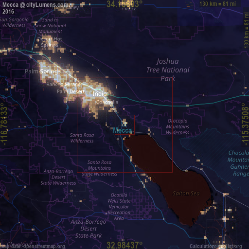
Analysis of Mecca night lights 2016
Square area 10x10 km:
 0%
0%90-99
0.73%80-89
0%70-79
1.65%60-69
0.92%50-59
2.56%40-49
2.01%30-39
1.28%20-29
0%10-19
0.55%0-9
90.29%Square area 50x50 km:
1.26%90-99
1.73%80-89
1.01%70-79
1.49%60-69
2.21%50-59
1.75%40-49
1.01%30-39
1.19%20-29
1.91%10-19
2.99%0-9
83.44%Clear (daylight) street map image can be seen on geolist.org.
Map coordinates:
34° 9' 21.7" North, 116° 46' 52.8" West
33° 34' 19.9" North, 116° 4' 41.5" West
32° 59' 3.7" North, 115° 22' 30.3" West
Some cities around Mecca sort by population:
• Indio
20.9 km =13 mi,  322°
322°
• Palm Desert
32.3 km =20.1 mi,  301°
301°
• Coachella
14.9 km =9.3 mi, 323°
• La Quinta
23.7 km =14.7 mi, 295°
• Rancho Mirage
36.1 km =22.4 mi, 301°
• Bermuda Dunes
27.2 km =16.9 mi,  314°
314°
• Oasis
12 km =7.5 mi,  189°
189°
• Indian Wells
29.4 km =18.3 mi, 303°
5371965 (p: 8,577)
Sources (retrieved 2019-11-25):
» Earth at Night: Flat Maps 2012, 2016