Coachella night lights from space
Night Light of Coachella (California) from space (United States) Src. Average luminocity for 10x10km area is 49.7454% and for 50x50km: 14.0356%.
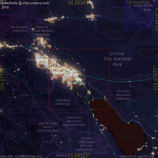

Analysis of Coachella night lights 2016
Square area 10x10 km:
 9.89%
9.89%90-99
9.52%80-89
5.31%70-79
7.14%60-69
6.41%50-59
7.14%40-49
6.23%30-39
10.99%20-29
14.47%10-19
15.2%0-9
7.69%Square area 50x50 km:
1.87%90-99
2.43%80-89
1.57%70-79
2.15%60-69
3.45%50-59
2.45%40-49
1.5%30-39
1.68%20-29
3.2%10-19
5.42%0-9
74.28%Clear (daylight) street map image can be seen on geolist.org.
Map coordinates:
34° 15' 48.3" North, 116° 52' 37.3" West
33° 40' 49.1" North, 116° 10' 26" West
33° 5' 35.6" North, 115° 28' 14.8" West
Some cities around Coachella sort by population:
• Indio
6 km =3.7 mi,  318°
318°
• Palm Desert
19.4 km =12.1 mi,  284°
284°
• La Quinta
12.7 km =7.9 mi,  261°
261°
• Rancho Mirage
23.1 km =14.4 mi,  286°
286°
• Mecca
14.9 km =9.3 mi,  143°
143°
• Bermuda Dunes
12.7 km =7.9 mi,  303°
303°
• Oasis
24.8 km =15.4 mi,  163°
163°
• Indian Wells
16.2 km =10.1 mi, 284°
5338166 (p: 44,635)
Sources (retrieved 2019-11-25):
» Earth at Night: Flat Maps 2012, 2016