Crestline night lights from space
Night Light of Crestline (California) from space (United States) Src. Average luminocity for 10x10km area is 17.7381% and for 50x50km: 33.5817%.
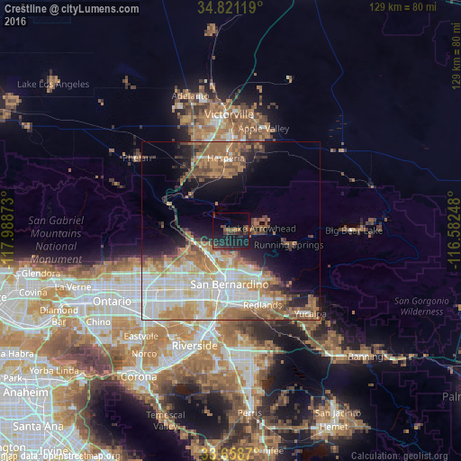
Analysis of Crestline night lights 2016
Square area 10x10 km:
 0%
0%90-99
0%80-89
0%70-79
0.18%60-69
3.11%50-59
3.48%40-49
3.48%30-39
7.88%20-29
14.65%10-19
27.84%0-9
39.38%Square area 50x50 km:
7.56%90-99
6.78%80-89
3.49%70-79
4.18%60-69
7.56%50-59
5.06%40-49
3.9%30-39
2.88%20-29
4.16%10-19
8.17%0-9
46.27%Clear (daylight) street map image can be seen on geolist.org.
Map coordinates:
34° 49' 16.3" North, 117° 59' 19.4" West
34° 14' 31" North, 117° 17' 8.2" West
33° 39' 31.3" North, 116° 34' 56.9" West
Some cities around Crestline sort by population:
• San Bernardino
14.9 km =9.3 mi,  181°
181°
• Rialto
17 km =10.6 mi,  207°
207°
• Hesperia
20.6 km =12.8 mi,  356°
356°
• Highland
14.5 km =9 mi,  150°
150°
• Colton
18.9 km =11.7 mi,  187°
187°
• Lake Arrowhead
8.9 km =5.5 mi,  85°
85°
• Muscoy
11.1 km =6.9 mi, 208°
• Oak Hills
18 km =11.2 mi,  330°
330°
5340674 (p: 10,770)
Sources (retrieved 2019-11-25):
» Earth at Night: Flat Maps 2012, 2016