Oak Grove night lights from space
Night Light of Oak Grove (South Carolina) from space (United States) Src. Average luminocity for 10x10km area is 12.6374% and for 50x50km: 27.3206%.
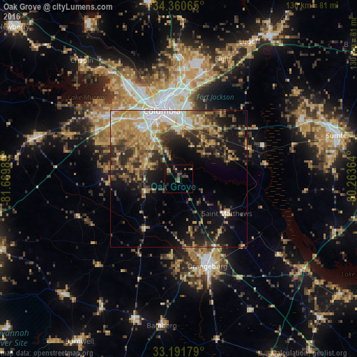
Analysis of Oak Grove night lights 2016
Square area 10x10 km:
 0.18%
0.18%90-99
0.55%80-89
0.92%70-79
1.28%60-69
2.56%50-59
1.83%40-49
5.49%30-39
3.3%20-29
2.56%10-19
6.23%0-9
75.09%Square area 50x50 km:
3.26%90-99
3.15%80-89
4.4%70-79
5.31%60-69
5.21%50-59
3.08%40-49
4.08%30-39
6.03%20-29
6.61%10-19
11.71%0-9
47.16%Clear (daylight) street map image can be seen on geolist.org.
Map coordinates:
34° 21' 38.3" North, 81° 40' 11.6" West
33° 46' 41.6" North, 80° 58' 0.3" West
33° 11' 30.4" North, 80° 15' 49.1" West
Some cities around Oak Grove sort by population:
• Columbia
25.5 km =15.8 mi,  345°
345°
• Saint Andrews
33.3 km =20.7 mi,  333°
333°
• West Columbia
25.9 km =16.1 mi,  337°
337°
• Dentsville
31.8 km =19.8 mi,  1°
1°
• Cayce
23.1 km =14.4 mi, 334°
• Forest Acres
26.9 km =16.7 mi,  355°
355°
• Red Bank
30.4 km =18.9 mi,  304°
304°
• Woodfield
31.4 km =19.5 mi,  6°
6°
4589590 (p: 8,183)
Sources (retrieved 2019-11-25):
» Earth at Night: Flat Maps 2012, 2016