Niles night lights from space
Night Light of Niles (Ohio) from space (United States) Src. Average luminocity for 10x10km area is 70.1234% and for 50x50km: 27.6266%.
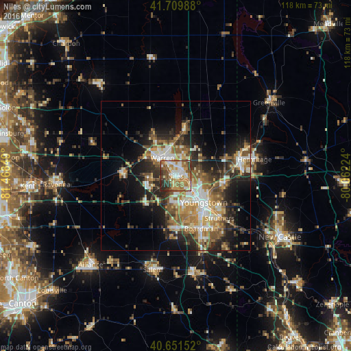
Analysis of Niles night lights 2016
Square area 10x10 km:
 13.15%
90-99
15.91%80-89
8.77%70-79
12.34%60-69
17.69%50-59
10.39%40-49
7.63%30-39
8.12%20-29
6.01%10-19
0%0-9
0%Square area 50x50 km:
3.67%90-99
4.96%80-89
3.18%70-79
3.86%60-69
4.96%50-59
5.07%40-49
3.89%30-39
4.45%20-29
8.37%10-19
10.1%0-9
47.49%Clear (daylight) street map image can be seen on geolist.org.
Map coordinates:
41° 42' 35.6" North, 81° 28' 6.6" West
41° 10' 58.2" North, 80° 45' 55.3" West
40° 39' 5.5" North, 80° 3' 44.1" West
Some cities around Niles sort by population:
• Youngstown
13.4 km =8.3 mi,  133°
133°
• Warren
7.5 km =4.7 mi,  323°
323°
• Austintown
9 km =5.6 mi,  179°
179°
• Girard
6.2 km =3.9 mi,  120°
120°
• Hubbard
16.7 km =10.4 mi,  100°
100°
• Cortland
16.7 km =10.4 mi,  11°
11°
• Champion Heights
13.7 km =8.5 mi,  330°
330°
• Howland Center
7.8 km =4.8 mi, 12°
5164582 (p: 18,651)
Sources (retrieved 2019-11-25):
» Earth at Night: Flat Maps 2012, 2016