Champion Heights night lights from space
Night Light of Champion Heights (Ohio) from space (United States) Src. Average luminocity for 10x10km area is 41.7062% and for 50x50km: 19.9931%.
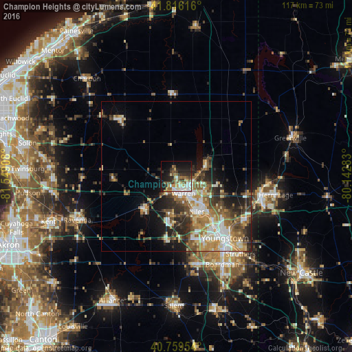
Analysis of Champion Heights night lights 2016
Square area 10x10 km:
 5.52%
5.52%90-99
9.42%80-89
4.87%70-79
4.71%60-69
5.03%50-59
8.12%40-49
6.33%30-39
5.52%20-29
12.82%10-19
21.43%0-9
16.23%Square area 50x50 km:
2.89%90-99
3.81%80-89
2.22%70-79
2.89%60-69
3.18%50-59
3.43%40-49
2.95%30-39
3.15%20-29
5.61%10-19
6.37%0-9
63.5%Clear (daylight) street map image can be seen on geolist.org.
Map coordinates:
41° 48' 58.2" North, 81° 32' 56.7" West
41° 17' 24" North, 80° 50' 45.4" West
40° 45' 34.3" North, 80° 8' 34.2" West
Some cities around Champion Heights sort by population:
• Youngstown
26.8 km =16.7 mi,  142°
142°
• Warren
6.3 km =3.9 mi,  158°
158°
• Austintown
22 km =13.7 mi, 161°
• Niles
13.7 km =8.5 mi,  150°
150°
• Girard
19.4 km =12.1 mi, 141°
• Hubbard
27.5 km =17.1 mi,  122°
122°
• Cortland
11 km =6.8 mi,  65°
65°
• Howland Center
9.4 km =5.8 mi, 117°
7259582 (p: 6,498)
Sources (retrieved 2019-11-25):
» Earth at Night: Flat Maps 2012, 2016