Greeneville night lights from space
Night Light of Greeneville (Tennessee) from space (United States) Src. Average luminocity for 10x10km area is 49.5647% and for 50x50km: 5.6349%.
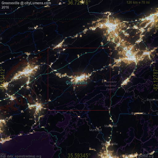
Analysis of Greeneville night lights 2016
Square area 10x10 km:
 9.27%
9.27%90-99
8.22%80-89
7.87%70-79
6.47%60-69
4.9%50-59
7.69%40-49
5.94%30-39
9.62%20-29
17.66%10-19
22.03%0-9
0.35%Square area 50x50 km:
0.55%90-99
0.49%80-89
0.73%70-79
0.55%60-69
0.63%50-59
1%40-49
0.7%30-39
1.42%20-29
1.7%10-19
4.43%0-9
87.8%Clear (daylight) street map image can be seen on geolist.org.
Map coordinates:
36° 43' 43.5" North, 83° 32' 2.8" West
36° 9' 47.4" North, 82° 49' 51.6" West
35° 35' 36.4" North, 82° 7' 40.3" West
Some cities around Greeneville sort by population:
• Johnson City
46 km =28.6 mi,  68°
68°
• Morristown
42 km =26.1 mi,  277°
277°
• Colonial Heights
46.3 km =28.8 mi,  39°
39°
• Newport
38.8 km =24.1 mi,  235°
235°
• Church Hill
41.3 km =25.7 mi,  14°
14°
• Erwin
37.2 km =23.1 mi,  93°
93°
• Mount Carmel
45.1 km =28 mi,  19°
19°
• Jonesborough
35.2 km =21.9 mi, 65°
4626334 (p: 15,094)
Sources (retrieved 2019-11-25):
» Earth at Night: Flat Maps 2012, 2016