Batesburg-Leesville night lights from space
Night Light of Batesburg-Leesville (South Carolina) from space (United States) Src. Average luminocity for 10x10km area is 28.4773% and for 50x50km: 10.2261%.
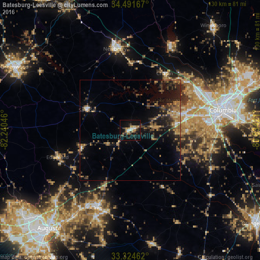
Analysis of Batesburg-Leesville night lights 2016
Square area 10x10 km:
 2.62%
2.62%90-99
3.5%80-89
5.42%70-79
4.72%60-69
3.32%50-59
1.05%40-49
3.67%30-39
6.47%20-29
5.07%10-19
37.59%0-9
26.57%Square area 50x50 km:
0.33%90-99
0.42%80-89
1.22%70-79
1.37%60-69
2.14%50-59
1.47%40-49
1.85%30-39
3.5%20-29
3.35%10-19
8.63%0-9
75.71%Clear (daylight) street map image can be seen on geolist.org.
Map coordinates:
34° 29' 30" North, 82° 14' 25.7" West
33° 54' 36.5" North, 81° 32' 14.4" West
33° 19' 28.6" North, 80° 50' 3.2" West
Some cities around Batesburg-Leesville sort by population:
• Saint Andrews
40.5 km =25.2 mi,  68°
68°
• Lexington
28.9 km =18 mi, 74°
• Seven Oaks
39.2 km =24.4 mi, 66°
• Irmo
38.1 km =23.7 mi,  59°
59°
• Newberry
41.2 km =25.6 mi,  349°
349°
• Oak Grove
37.2 km =23.1 mi,  77°
77°
• Red Bank
27.7 km =17.2 mi, 84°
• Lake Murray of Richland
34.3 km =21.3 mi,  47°
47°
4570117 (p: 5,441)
Sources (retrieved 2019-11-25):
» Earth at Night: Flat Maps 2012, 2016