Kaser night lights from space
Night Light of Kaser (New York) from space (United States) Src. Average luminocity for 10x10km area is 70.0341% and for 50x50km: 47.4396%.
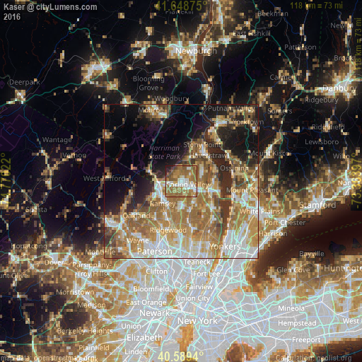
Analysis of Kaser night lights 2016
Square area 10x10 km:
 12.18%
90-99
12.99%80-89
5.52%70-79
9.58%60-69
32.63%50-59
17.21%40-49
3.57%30-39
2.27%20-29
2.92%10-19
1.14%0-9
0%Square area 50x50 km:
7.94%90-99
8.38%80-89
6.07%70-79
8.98%60-69
12.07%50-59
7.59%40-49
5.15%30-39
4.58%20-29
7.16%10-19
9.7%0-9
22.38%Clear (daylight) street map image can be seen on geolist.org.
Map coordinates:
41° 38' 55.5" North, 74° 46' 12.8" West
41° 7' 16.4" North, 74° 4' 1.5" West
40° 35' 21.8" North, 73° 21' 50.3" West
Some cities around Kaser sort by population:
• Spring Valley
2.2 km =1.4 mi,  114°
114°
• Monsey
1.1 km =0.7 mi,  185°
185°
• Chestnut Ridge
4.2 km =2.6 mi,  166°
166°
• New Square
3.8 km =2.4 mi,  57°
57°
• Hillcrest
2.3 km =1.4 mi,  71°
71°
• Viola
2.1 km =1.3 mi,  323°
323°
• Wesley Hills
4.2 km =2.6 mi,  356°
356°
• New Hempstead
4.2 km =2.6 mi,  41°
41°
5123109 (p: 5,131)
Sources (retrieved 2019-11-25):
» Earth at Night: Flat Maps 2012, 2016