Nelsonville night lights from space
Night Light of Nelsonville (Ohio) from space (United States) Src. Average luminocity for 10x10km area is 12.6905% and for 50x50km: 3.457%.
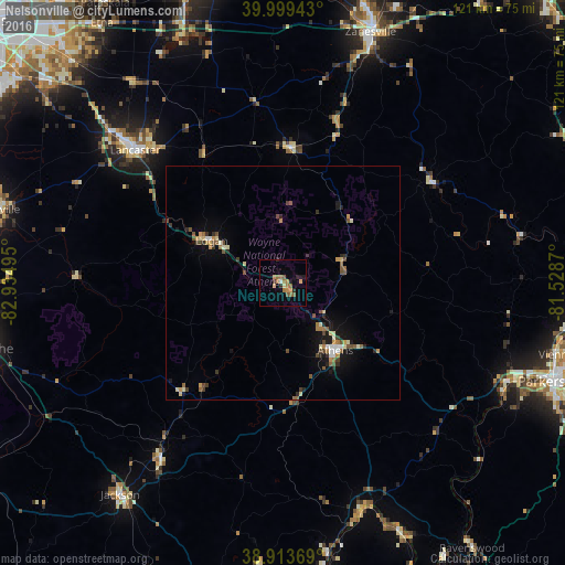
Analysis of Nelsonville night lights 2016
Square area 10x10 km:
 0.51%
0.51%90-99
0.17%80-89
2.04%70-79
1.7%60-69
5.1%50-59
3.06%40-49
0.34%30-39
1.36%20-29
1.87%10-19
1.87%0-9
81.97%Square area 50x50 km:
0.18%90-99
0.38%80-89
0.46%70-79
0.39%60-69
0.59%50-59
0.64%40-49
0.59%30-39
0.47%20-29
0.55%10-19
1.95%0-9
93.8%Clear (daylight) street map image can be seen on geolist.org.
Map coordinates:
39° 59' 57.9" North, 82° 56' 5.8" West
39° 27' 31.2" North, 82° 13' 54.6" West
38° 54' 49.3" North, 81° 31' 43.3" West
Some cities around Nelsonville sort by population:
• Lancaster
42.4 km =26.3 mi,  311°
311°
• Zanesville
56.7 km =35.2 mi,  19°
19°
• Athens
18.2 km =11.3 mi,  142°
142°
• Logan
17.6 km =10.9 mi,  301°
301°
• Belpre
60.3 km =37.5 mi,  109°
109°
• Geneva
28.5 km =17.7 mi,  322°
322°
• Jackson
57.1 km =35.5 mi,  217°
217°
• Wellston
45.4 km =28.2 mi,  214°
214°
4519445 (p: 5,197)
Sources (retrieved 2019-11-25):
» Earth at Night: Flat Maps 2012, 2016