Muscatine night lights from space
Night Light of Muscatine (Iowa) from space (United States) Src. Average luminocity for 10x10km area is 39.568% and for 50x50km: 3.7923%.

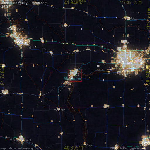
Analysis of Muscatine night lights 2016
Square area 10x10 km:
 7.31%
7.31%90-99
9.18%80-89
2.04%70-79
5.95%60-69
5.27%50-59
7.14%40-49
1.53%30-39
4.08%20-29
11.39%10-19
28.74%0-9
17.35%Square area 50x50 km:
0.45%90-99
0.64%80-89
0.26%70-79
0.47%60-69
0.46%50-59
0.65%40-49
0.31%30-39
0.6%20-29
0.9%10-19
2.71%0-9
92.55%Clear (daylight) street map image can be seen on geolist.org.
Map coordinates:
41° 56' 58.4" North, 91° 44' 46.8" West
41° 25' 28.1" North, 91° 2' 35.6" West
40° 53' 42.4" North, 90° 20' 24.3" West
Some cities around Muscatine sort by population:
• Davenport
40.3 km =25 mi,  74°
74°
• Iowa City
48.3 km =30 mi,  302°
302°
• Moline
44.9 km =27.9 mi,  78°
78°
• Rock Island
39.8 km =24.7 mi, 76°
• Bettendorf
45.3 km =28.1 mi, 75°
• East Moline
50.6 km =31.4 mi, 80°
• Eldridge
46.2 km =28.7 mi,  55°
55°
• Milan
39.4 km =24.5 mi,  85°
85°
4868404 (p: 23,968)
Sources (retrieved 2019-11-25):
» Earth at Night: Flat Maps 2012, 2016