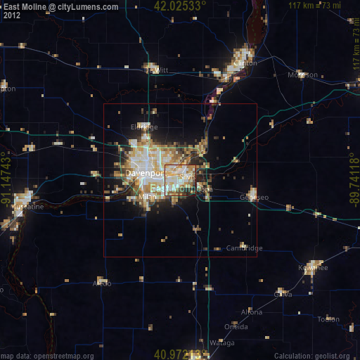
East Moline night lights from space
Night Light of East Moline (Illinois) from space (United States) Src. Average luminocity for 10x10km area is 79.2024% and for 50x50km: 18.7076%.

Analysis of East Moline night lights 2016
Square area 10x10 km:
 19.39%
90-99
24.66%80-89
12.41%70-79
13.61%60-69
10.71%50-59
7.99%40-49
3.91%30-39
3.91%20-29
3.4%10-19
0%0-9
0%Square area 50x50 km:
3.36%90-99
3.45%80-89
2.91%70-79
2.43%60-69
2.27%50-59
2.36%40-49
2.31%30-39
2.87%20-29
4.64%10-19
6.69%0-9
66.72%Clear (daylight) street map image can be seen on geolist.org.
Map coordinates:
42° 1' 31.2" North, 91° 8' 50.7" West
41° 30' 3.1" North, 90° 26' 39.5" West
40° 58' 19.7" North, 89° 44' 28.2" West
Some cities around East Moline sort by population:
• Davenport
11.4 km =7.1 mi,  282°
282°
• Moline
5.9 km =3.7 mi, 276°
• Rock Island
11.2 km =7 mi,  274°
274°
• Bettendorf
6.5 km =4 mi,  293°
293°
• Silvis
2.7 km =1.7 mi,  62°
62°
• Eldridge
21 km =13 mi,  326°
326°
• Colona
7.8 km =4.8 mi,  103°
103°
• Milan
11.9 km =7.4 mi,  243°
243°
4890536 (p: 21,350)
Sources (retrieved 2019-11-25):
» Earth at Night: Flat Maps 2012, 2016