Augusta night lights from space
Night Light of Augusta (Kansas) from space (United States) Src. Average luminocity for 10x10km area is 13.5153% and for 50x50km: 10.3867%.
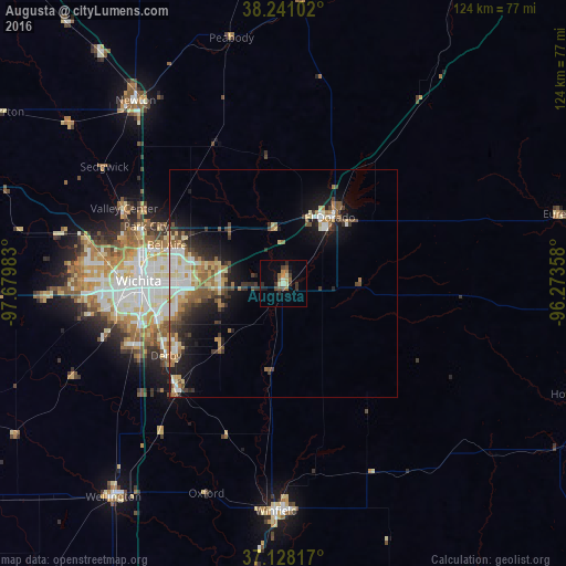
Analysis of Augusta night lights 2016
Square area 10x10 km:
 0%
0%90-99
2.04%80-89
2.04%70-79
1.19%60-69
1.53%50-59
3.06%40-49
2.72%30-39
2.21%20-29
3.74%10-19
2.72%0-9
78.74%Square area 50x50 km:
1.38%90-99
1.53%80-89
1.71%70-79
0.87%60-69
1.8%50-59
1.66%40-49
1.36%30-39
1.91%20-29
2.25%10-19
5.61%0-9
79.92%Clear (daylight) street map image can be seen on geolist.org.
Map coordinates:
38° 14' 27.7" North, 97° 40' 47.4" West
37° 41' 12" North, 96° 58' 36.1" West
37° 7' 41.4" North, 96° 16' 24.9" West
Some cities around Augusta sort by population:
• Wichita
31.8 km =19.8 mi,  271°
271°
• Derby
30.1 km =18.7 mi,  238°
238°
• El Dorado
17.7 km =11 mi,  34°
34°
• Andover
14.4 km =8.9 mi,  282°
282°
• Haysville
35.8 km =22.2 mi,  247°
247°
• Park City
32.6 km =20.3 mi,  292°
292°
• Valley Center
38.6 km =24 mi,  295°
295°
• Mulvane
33.3 km =20.7 mi,  224°
224°
4267773 (p: 9,299)
Sources (retrieved 2019-11-25):
» Earth at Night: Flat Maps 2012, 2016