Mount Zion night lights from space
Night Light of Mount Zion (Illinois) from space (United States) Src. Average luminocity for 10x10km area is 24.6718% and for 50x50km: 8.7812%.
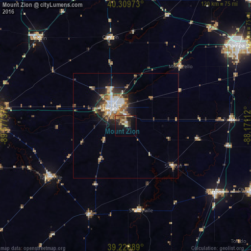
Analysis of Mount Zion night lights 2016
Square area 10x10 km:
 1.02%
1.02%90-99
0.68%80-89
4.42%70-79
5.1%60-69
3.74%50-59
5.27%40-49
5.1%30-39
4.42%20-29
8.16%10-19
17.86%0-9
44.22%Square area 50x50 km:
1.28%90-99
1.39%80-89
1.13%70-79
1.16%60-69
1.18%50-59
1.56%40-49
1.21%30-39
1.48%20-29
1.92%10-19
4.29%0-9
83.39%Clear (daylight) street map image can be seen on geolist.org.
Map coordinates:
40° 18' 35" North, 89° 34' 38.5" West
39° 46' 17.1" North, 88° 52' 27.3" West
39° 13' 44" North, 88° 10' 16" West
Some cities around Mount Zion sort by population:
• Decatur
10.3 km =6.4 mi,  318°
318°
• Mattoon
53.6 km =33.3 mi,  126°
126°
• Lincoln
59.2 km =36.8 mi, 315°
• Taylorville
43.7 km =27.2 mi,  235°
235°
• Savoy
61.7 km =38.3 mi,  59°
59°
• Clinton
43.2 km =26.8 mi,  349°
349°
• Pana
46 km =28.6 mi,  202°
202°
• Monticello
38.4 km =23.9 mi,  41°
41°
4245174 (p: 5,862)
Sources (retrieved 2019-11-25):
» Earth at Night: Flat Maps 2012, 2016