Shamokin night lights from space
Night Light of Shamokin (Pennsylvania) from space (United States) Src. Average luminocity for 10x10km area is 13.8344% and for 50x50km: 6.0026%.
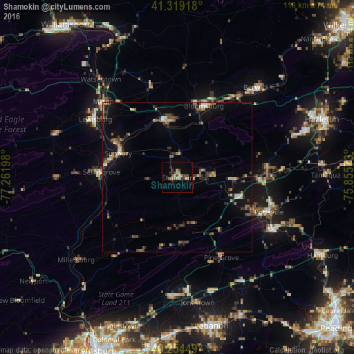
Analysis of Shamokin night lights 2016
Square area 10x10 km:
 0.32%
0.32%90-99
0.32%80-89
3.41%70-79
2.27%60-69
1.79%50-59
1.3%40-49
3.41%30-39
2.92%20-29
1.3%10-19
3.41%0-9
79.55%Square area 50x50 km:
0.26%90-99
0.4%80-89
0.8%70-79
0.76%60-69
0.72%50-59
1.14%40-49
1.04%30-39
1.36%20-29
1.12%10-19
3.96%0-9
88.43%Clear (daylight) street map image can be seen on geolist.org.
Map coordinates:
41° 19' 9" North, 77° 15' 43.1" West
40° 47' 20.3" North, 76° 33' 31.9" West
40° 15' 16.2" North, 75° 51' 20.6" West
Some cities around Shamokin sort by population:
• Bloomsburg
25.4 km =15.8 mi,  20°
20°
• Pottsville
32.7 km =20.3 mi,  110°
110°
• Sunbury
21.4 km =13.3 mi,  292°
292°
• Milton
34.7 km =21.6 mi,  315°
315°
• Selinsgrove
25.6 km =15.9 mi,  272°
272°
• Lewisburg
33.6 km =20.9 mi,  305°
305°
• Mount Carmel
12.4 km =7.7 mi,  85°
85°
• Schuylkill Haven
37.1 km =23.1 mi,  118°
118°
5211622 (p: 7,162)
Sources (retrieved 2019-11-25):
» Earth at Night: Flat Maps 2012, 2016