Morris Plains night lights from space
Night Light of Morris Plains (New Jersey) from space (United States) Src. Average luminocity for 10x10km area is 73.5085% and for 50x50km: 52.7768%.
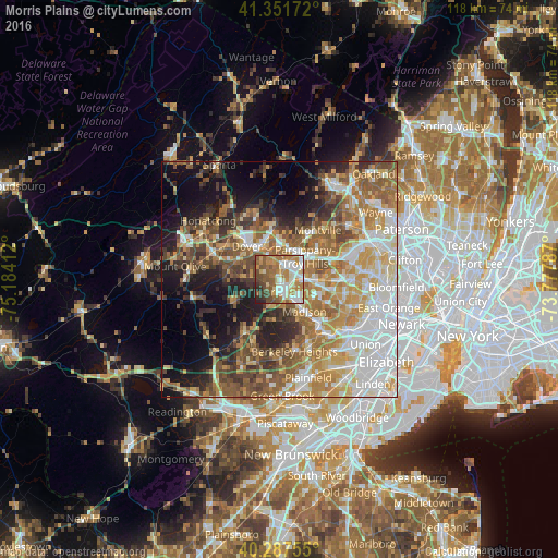
Analysis of Morris Plains night lights 2016
Square area 10x10 km:
 14.63%
90-99
18.03%80-89
8.16%70-79
15.48%60-69
15.65%50-59
12.93%40-49
9.18%30-39
2.38%20-29
3.57%10-19
0%0-9
0%Square area 50x50 km:
11.22%90-99
9.41%80-89
6.88%70-79
9%60-69
9.53%50-59
8.91%40-49
7.06%30-39
5.4%20-29
7.05%10-19
11.16%0-9
14.38%Clear (daylight) street map image can be seen on geolist.org.
Map coordinates:
41° 21' 6.2" North, 75° 11' 2.8" West
40° 49' 18.4" North, 74° 28' 51.6" West
40° 17' 15.2" North, 73° 46' 40.3" West
Some cities around Morris Plains sort by population:
• Parsippany
6.1 km =3.8 mi,  49°
49°
• Randolph
9 km =5.6 mi,  289°
289°
• Dover
9.7 km =6 mi,  315°
315°
• Madison
8.7 km =5.4 mi,  142°
142°
• Hanover
9.8 km =6.1 mi,  101°
101°
• East Hanover
9.8 km =6.1 mi,  91°
91°
• Florham Park
8.7 km =5.4 mi,  115°
115°
• Rockaway
9.3 km =5.8 mi,  342°
342°
5101417 (p: 5,532)
Sources (retrieved 2019-11-25):
» Earth at Night: Flat Maps 2012, 2016