Rockaway night lights from space
Night Light of Rockaway (New Jersey) from space (United States) Src. Average luminocity for 10x10km area is 65.7772% and for 50x50km: 40.3193%.
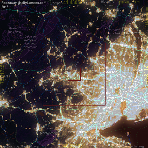
Analysis of Rockaway night lights 2016
Square area 10x10 km:
 11.39%
90-99
11.9%80-89
7.14%70-79
8.67%60-69
20.24%50-59
15.99%40-49
9.52%30-39
7.14%20-29
6.63%10-19
1.36%0-9
0%Square area 50x50 km:
6.45%90-99
6.3%80-89
5.14%70-79
7.25%60-69
7.88%50-59
6.79%40-49
5.99%30-39
5.15%20-29
7.52%10-19
13.56%0-9
27.97%Clear (daylight) street map image can be seen on geolist.org.
Map coordinates:
41° 25' 49.9" North, 75° 13' 2.8" West
40° 54' 4.4" North, 74° 30' 51.6" West
40° 22' 3.5" North, 73° 48' 40.3" West
Some cities around Rockaway sort by population:
• Parsippany
8.9 km =5.5 mi,  122°
122°
• Randolph
8.2 km =5.1 mi,  223°
223°
• Dover
4.4 km =2.7 mi,  244°
244°
• White Meadow Lake
2.5 km =1.6 mi,  6°
6°
• Boonton
9 km =5.6 mi,  89°
89°
• Wharton
5.7 km =3.5 mi,  261°
261°
• Morris Plains
9.3 km =5.8 mi,  162°
162°
• Mount Arlington
10.5 km =6.5 mi,  285°
285°
5103396 (p: 6,494)
Sources (retrieved 2019-11-25):
» Earth at Night: Flat Maps 2012, 2016