Montgomery night lights from space
Night Light of Montgomery (Illinois) from space (United States) Src. Average luminocity for 10x10km area is 83.638% and for 50x50km: 50.7434%.
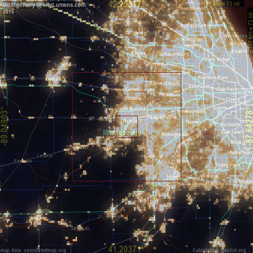
Analysis of Montgomery night lights 2016
Square area 10x10 km:
 25.32%
90-99
25.81%80-89
9.58%70-79
14.77%60-69
12.99%50-59
7.79%40-49
2.92%30-39
0.81%20-29
0%10-19
0%0-9
0%Square area 50x50 km:
10.61%90-99
12.29%80-89
10.03%70-79
9.97%60-69
8%50-59
4.08%40-49
2.61%30-39
3.18%20-29
4.24%10-19
7.56%0-9
27.42%Clear (daylight) street map image can be seen on geolist.org.
Map coordinates:
42° 15' 11.4" North, 89° 2' 56.5" West
41° 43' 50.1" North, 88° 20' 45.2" West
41° 12' 13.4" North, 87° 38' 34" West
Some cities around Montgomery sort by population:
• Aurora
4 km =2.5 mi,  32°
32°
• Oswego
5.3 km =3.3 mi,  184°
184°
• Batavia
13.6 km =8.5 mi,  11°
11°
• Yorkville
13 km =8.1 mi,  220°
220°
• North Aurora
8.5 km =5.3 mi, 10°
• Sugar Grove
8.8 km =5.5 mi,  292°
292°
• Boulder Hill
2.2 km =1.4 mi,  158°
158°
• Lynwood
6.6 km =4.1 mi, 217°
4902559 (p: 19,489)
Sources (retrieved 2019-11-25):
» Earth at Night: Flat Maps 2012, 2016