Monroe night lights from space
Night Light of Monroe (Washington) from space (United States) Src. Average luminocity for 10x10km area is 16.794% and for 50x50km: 21.9941%.
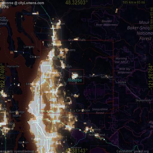
Analysis of Monroe night lights 2016
Square area 10x10 km:
 3.98%
3.98%90-99
3.98%80-89
1.14%70-79
0.85%60-69
1.14%50-59
0.85%40-49
1.7%30-39
1.56%20-29
0.85%10-19
13.21%0-9
70.74%Square area 50x50 km:
4.36%90-99
4.61%80-89
1.95%70-79
3.58%60-69
4.06%50-59
2.53%40-49
2.73%30-39
3.62%20-29
4.42%10-19
5.36%0-9
62.76%Clear (daylight) street map image can be seen on geolist.org.
Map coordinates:
48° 19' 30.1" North, 122° 40' 26.7" West
47° 51' 19.4" North, 121° 58' 15.5" West
47° 22' 53.1" North, 121° 16' 4.2" West
Some cities around Monroe sort by population:
• North Creek
15.8 km =9.8 mi,  255°
255°
• Cottage Lake
14.7 km =9.1 mi,  212°
212°
• Silver Firs
13.8 km =8.6 mi,  274°
274°
• Mill Creek East
16.3 km =10.1 mi, 262°
• Maltby
12 km =7.5 mi,  242°
242°
• Snohomish
11.4 km =7.1 mi,  303°
303°
• Duvall
12.6 km =7.8 mi,  184°
184°
• Woods Creek
6 km =3.7 mi,  64°
64°
5803786 (p: 18,090)
Sources (retrieved 2019-11-25):
» Earth at Night: Flat Maps 2012, 2016