Willow Street night lights from space
Night Light of Willow Street (Pennsylvania) from space (United States) Src. Average luminocity for 10x10km area is 33.4898% and for 50x50km: 19.0981%.
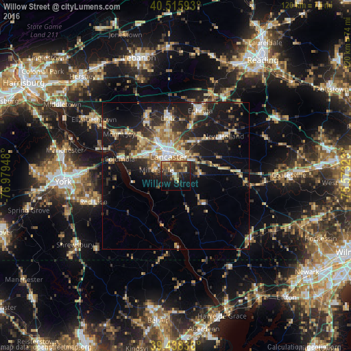
Analysis of Willow Street night lights 2016
Square area 10x10 km:
 1.36%
1.36%90-99
1.7%80-89
5.78%70-79
4.25%60-69
5.27%50-59
8.5%40-49
8.84%30-39
8.84%20-29
12.93%10-19
21.6%0-9
20.92%Square area 50x50 km:
2%90-99
2.33%80-89
3.3%70-79
2.35%60-69
3.06%50-59
2.45%40-49
2.7%30-39
3.17%20-29
6.16%10-19
15.53%0-9
56.97%Clear (daylight) street map image can be seen on geolist.org.
Map coordinates:
40° 30' 57.3" North, 76° 58' 46.1" West
39° 58' 45.4" North, 76° 16' 34.9" West
39° 26' 18.1" North, 75° 34' 23.6" West
Some cities around Willow Street sort by population:
• Lancaster
7 km =4.3 mi,  339°
339°
• Ephrata
23.8 km =14.8 mi,  20°
20°
• Columbia
20.3 km =12.6 mi,  287°
287°
• Lititz
20 km =12.4 mi,  352°
352°
• Millersville
6.9 km =4.3 mi, 287°
• Mount Joy
24.2 km =15 mi,  306°
306°
• Leola
14.4 km =8.9 mi,  32°
32°
• New Holland
21.2 km =13.2 mi,  50°
50°
4562275 (p: 7,578)
Sources (retrieved 2019-11-25):
» Earth at Night: Flat Maps 2012, 2016