Buechel night lights from space
Night Light of Buechel (Kentucky) from space (United States) Src. Average luminocity for 10x10km area is 96.8537% and for 50x50km: 50.249%.
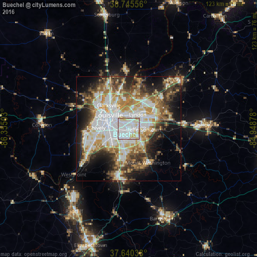
Analysis of Buechel night lights 2016
Square area 10x10 km:
 51.36%
90-99
34.86%80-89
10.88%70-79
2.89%60-69
0%50-59
0%40-49
0%30-39
0%20-29
0%10-19
0%0-9
0%Square area 50x50 km:
13.01%90-99
11.37%80-89
6.67%70-79
6.19%60-69
6.43%50-59
5.58%40-49
6%30-39
6.23%20-29
7.84%10-19
10.67%0-9
20.01%Clear (daylight) street map image can be seen on geolist.org.
Map coordinates:
38° 44' 44" North, 86° 21' 18.1" West
38° 11' 42.3" North, 85° 39' 6.8" West
37° 38' 25.4" North, 84° 56' 55.6" West
Some cities around Buechel sort by population:
• Jeffersontown
7.6 km =4.7 mi,  90°
90°
• Newburg
4 km =2.5 mi,  189°
189°
• Fern Creek
6.8 km =4.2 mi,  124°
124°
• Saint Matthews
6.4 km =4 mi,  356°
356°
• Okolona
6.8 km =4.2 mi,  207°
207°
• Highview
6.3 km =3.9 mi,  157°
157°
• Lyndon
8.1 km =5 mi,  32°
32°
• Douglass Hills
9.9 km =6.2 mi,  61°
61°
4286054 (p: 7,287)
Sources (retrieved 2019-11-25):
» Earth at Night: Flat Maps 2012, 2016