Tucson Estates night lights from space
Night Light of Tucson Estates (Arizona) from space (United States) Src. Average luminocity for 10x10km area is 28.8444% and for 50x50km: 26.4674%.
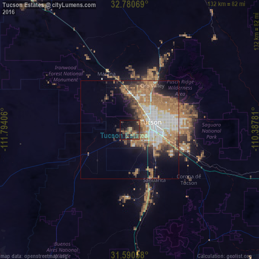
Analysis of Tucson Estates night lights 2016
Square area 10x10 km:
 0%
0%90-99
0%80-89
0%70-79
4.37%60-69
7.52%50-59
4.9%40-49
14.16%30-39
9.79%20-29
18.71%10-19
20.98%0-9
19.58%Square area 50x50 km:
5.01%90-99
4.72%80-89
1.61%70-79
4.42%60-69
7.93%50-59
4.14%40-49
3.02%30-39
2.9%20-29
3.65%10-19
6.64%0-9
55.95%Clear (daylight) street map image can be seen on geolist.org.
Map coordinates:
32° 46' 50.5" North, 111° 47' 38.6" West
32° 11' 15.3" North, 111° 5' 27.3" West
31° 35' 26.1" North, 110° 23' 16.1" West
Some cities around Tucson Estates sort by population:
• Casas Adobes
17.6 km =10.9 mi,  30°
30°
• Catalina Foothills
20.3 km =12.6 mi,  52°
52°
• Drexel Heights
7.8 km =4.8 mi,  131°
131°
• Flowing Wells
14.1 km =8.8 mi, 32°
• Picture Rocks
22.9 km =14.2 mi,  320°
320°
• Valencia West
6.5 km =4 mi,  199°
199°
• South Tucson
11.6 km =7.2 mi,  83°
83°
• Summit
18.8 km =11.7 mi,  135°
135°
5318320 (p: 12,192)
Sources (retrieved 2019-11-25):
» Earth at Night: Flat Maps 2012, 2016