Malibu night lights from space
Night Light of Malibu (California) from space (United States) Src. Average luminocity for 10x10km area is 16.5192% and for 50x50km: 20.878%.
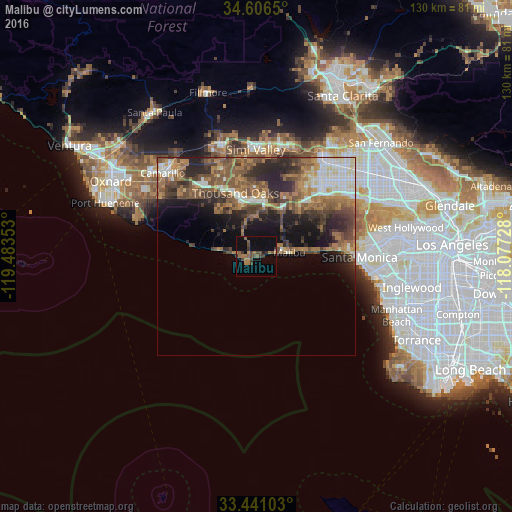
Analysis of Malibu night lights 2016
Square area 10x10 km:
 0%
0%90-99
0%80-89
0%70-79
2.27%60-69
5.24%50-59
4.37%40-49
5.42%30-39
4.72%20-29
0.7%10-19
8.22%0-9
69.06%Square area 50x50 km:
2.6%90-99
2.71%80-89
1.61%70-79
2.34%60-69
5.28%50-59
4.67%40-49
5.03%30-39
3.82%20-29
6.18%10-19
7.22%0-9
58.54%Clear (daylight) street map image can be seen on geolist.org.
Map coordinates:
34° 36' 23.4" North, 119° 29' 0.7" West
34° 1' 32.8" North, 118° 46' 49.4" West
33° 26' 27.7" North, 118° 4' 38.2" West
Some cities around Malibu sort by population:
• Thousand Oaks
16.9 km =10.5 mi,  341°
341°
• Calabasas
19.7 km =12.2 mi,  41°
41°
• Agoura Hills
12.3 km =7.6 mi,  2°
2°
• Agoura
13.6 km =8.5 mi,  16°
16°
• Oak Park
17.1 km =10.6 mi,  5°
5°
• Westlake Village
13.6 km =8.5 mi,  350°
350°
• Topanga
18.1 km =11.2 mi,  65°
65°
• Las Flores
13.4 km =8.3 mi,  84°
84°
5369906 (p: 12,965)
Sources (retrieved 2019-11-25):
» Earth at Night: Flat Maps 2012, 2016