Lutz night lights from space
Night Light of Lutz (Florida) from space (United States) Src. Average luminocity for 10x10km area is 72.6534% and for 50x50km: 62.319%.
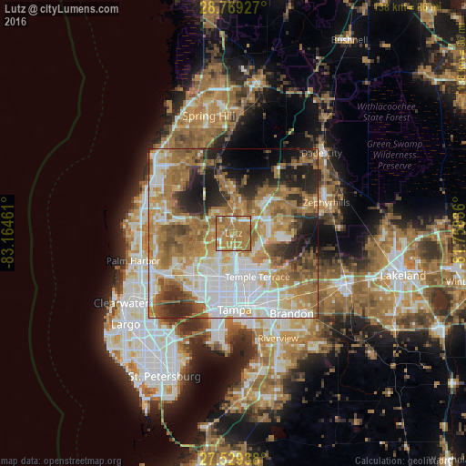
Analysis of Lutz night lights 2016
Square area 10x10 km:
 5.68%
5.68%90-99
8.14%80-89
4.36%70-79
21.97%60-69
57.39%50-59
2.46%40-49
0%30-39
0%20-29
0%10-19
0%0-9
0%Square area 50x50 km:
14.64%90-99
11.35%80-89
6.53%70-79
9.51%60-69
19.57%50-59
7.18%40-49
5.81%30-39
4.65%20-29
8.03%10-19
8.17%0-9
4.55%Clear (daylight) street map image can be seen on geolist.org.
Map coordinates:
28° 46' 9.4" North, 83° 9' 52.6" West
28° 9' 4" North, 82° 27' 41.3" West
27° 31' 45.8" North, 81° 45' 30.1" West
Some cities around Lutz sort by population:
• University
8.9 km =5.5 mi,  165°
165°
• Carrollwood Village
11 km =6.8 mi,  212°
212°
• Land O' Lakes
7.5 km =4.7 mi,  2°
2°
• Lake Magdalene
8.6 km =5.3 mi,  186°
186°
• Greater Northdale
8.1 km =5 mi,  231°
231°
• Northdale
7.7 km =4.8 mi, 214°
• Cheval
5.2 km =3.2 mi,  266°
266°
• Pebble Creek
11.4 km =7.1 mi,  91°
91°
4163033 (p: 19,344)
Sources (retrieved 2019-11-25):
» Earth at Night: Flat Maps 2012, 2016