Lewisburg night lights from space
Night Light of Lewisburg (Pennsylvania) from space (United States) Src. Average luminocity for 10x10km area is 28.085% and for 50x50km: 5.3867%.
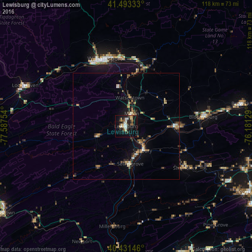
Analysis of Lewisburg night lights 2016
Square area 10x10 km:
 3.91%
3.91%90-99
4.25%80-89
5.1%70-79
3.06%60-69
1.36%50-59
2.21%40-49
3.57%30-39
5.27%20-29
7.48%10-19
30.95%0-9
32.82%Square area 50x50 km:
0.35%90-99
0.49%80-89
0.8%70-79
0.69%60-69
0.54%50-59
0.84%40-49
0.79%30-39
1.25%20-29
1.02%10-19
3.78%0-9
89.47%Clear (daylight) street map image can be seen on geolist.org.
Map coordinates:
41° 29' 36" North, 77° 35' 15.1" West
40° 57' 52.3" North, 76° 53' 3.9" West
40° 25' 53.3" North, 76° 10' 52.6" West
Some cities around Lewisburg sort by population:
• Williamsport
32.3 km =20.1 mi,  342°
342°
• Bloomsburg
36.3 km =22.6 mi,  83°
83°
• Sunbury
13.6 km =8.5 mi,  146°
146°
• Shamokin
33.6 km =20.9 mi,  125°
125°
• Milton
6.1 km =3.8 mi,  30°
30°
• South Williamsport
31.3 km =19.4 mi, 342°
• Selinsgrove
18.5 km =11.5 mi,  174°
174°
• Mount Carmel
43.9 km =27.3 mi,  115°
115°
5197842 (p: 5,774)
Sources (retrieved 2019-11-25):
» Earth at Night: Flat Maps 2012, 2016