Lakehills night lights from space
Night Light of Lakehills (Texas) from space (United States) Src. Average luminocity for 10x10km area is 3.1766% and for 50x50km: 8.0424%.
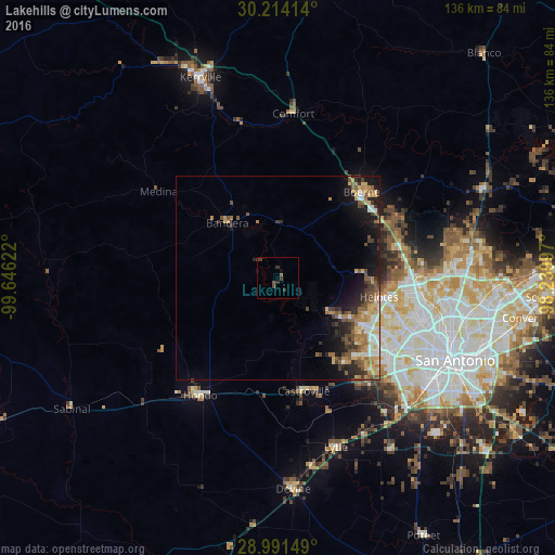
Analysis of Lakehills night lights 2016
Square area 10x10 km:
 0%
0%90-99
0%80-89
0%70-79
0%60-69
0%50-59
0.79%40-49
2.38%30-39
3.37%20-29
0.2%10-19
0.6%0-9
92.66%Square area 50x50 km:
0.83%90-99
0.99%80-89
0.98%70-79
1.46%60-69
1.36%50-59
1.64%40-49
1.23%30-39
1.38%20-29
1.73%10-19
4.57%0-9
83.83%Clear (daylight) street map image can be seen on geolist.org.
Map coordinates:
30° 12' 50.9" North, 99° 38' 46.4" West
29° 36' 16.8" North, 98° 56' 35.1" West
28° 59' 29.4" North, 98° 14' 23.9" West
Some cities around Lakehills sort by population:
• San Antonio
47.9 km =29.8 mi,  114°
114°
• Boerne
29.4 km =18.3 mi,  43°
43°
• Timberwood Park
46.3 km =28.8 mi,  75°
75°
• Leon Valley
33.7 km =20.9 mi, 111°
• Lackland Air Force Base
39.7 km =24.7 mi,  127°
127°
• Hondo
34.4 km =21.4 mi,  213°
213°
• Helotes
24.7 km =15.3 mi,  96°
96°
• Fair Oaks Ranch
32.9 km =20.4 mi,  61°
61°
4704940 (p: 5,150)
Sources (retrieved 2019-11-25):
» Earth at Night: Flat Maps 2012, 2016