Timberwood Park night lights from space
Night Light of Timberwood Park (Texas) from space (United States) Src. Average luminocity for 10x10km area is 40.9147% and for 50x50km: 35.9218%.
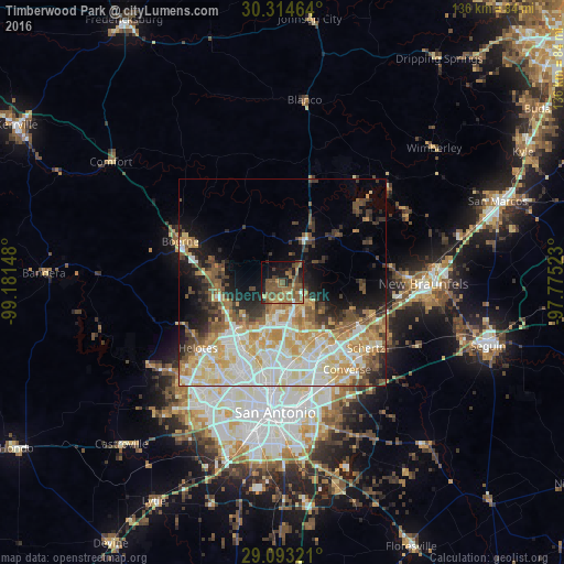
Analysis of Timberwood Park night lights 2016
Square area 10x10 km:
 1.19%
1.19%90-99
0.4%80-89
3.17%70-79
5.56%60-69
11.71%50-59
24.01%40-49
12.3%30-39
4.56%20-29
5.75%10-19
21.23%0-9
10.12%Square area 50x50 km:
6.99%90-99
8.23%80-89
5.87%70-79
5.93%60-69
4.02%50-59
5.03%40-49
3.99%30-39
3.96%20-29
4.53%10-19
8.28%0-9
43.17%Clear (daylight) street map image can be seen on geolist.org.
Map coordinates:
30° 18' 52.7" North, 99° 10' 53.3" West
29° 42' 20.8" North, 98° 28' 42.1" West
29° 5' 35.6" North, 97° 46' 30.8" West
Some cities around Timberwood Park sort by population:
• Universal City
25.2 km =15.7 mi,  134°
134°
• Live Oak
20.8 km =12.9 mi,  138°
138°
• Selma
21.4 km =13.3 mi, 128°
• Helotes
24.9 km =15.5 mi,  235°
235°
• Alamo Heights
24.6 km =15.3 mi,  177°
177°
• Fair Oaks Ranch
16.5 km =10.3 mi,  285°
285°
• Windcrest
23.2 km =14.4 mi,  155°
155°
• Terrell Hills
25.8 km =16 mi,  174°
174°
4736922 (p: 13,447)
Sources (retrieved 2019-11-25):
» Earth at Night: Flat Maps 2012, 2016