Lake Worth Corridor night lights from space
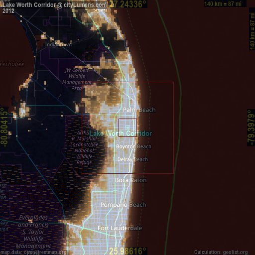
Night Light of Lake Worth Corridor (Florida) from space (United States) Src. Average luminocity for 10x10km area is 98.1572% and for 50x50km: 41.3106%.
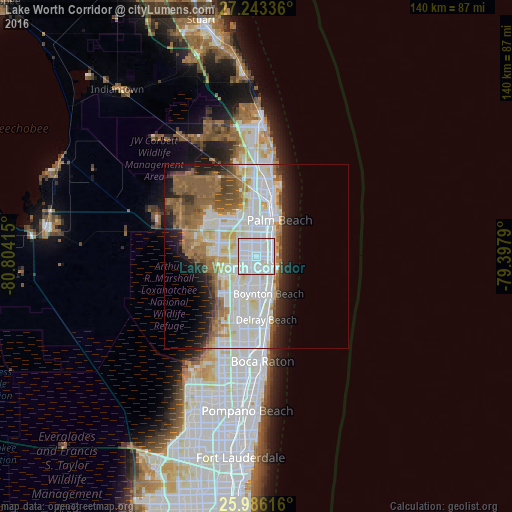
Analysis of Lake Worth Corridor night lights 2016
Square area 10x10 km:
 45.27%
90-99
51.33%80-89
3.41%70-79
0%60-69
0%50-59
0%40-49
0%30-39
0%20-29
0%10-19
0%0-9
0%Square area 50x50 km:
12.2%90-99
12.2%80-89
3.7%70-79
2.61%60-69
6.38%50-59
5.99%40-49
3.25%30-39
2.42%20-29
4.98%10-19
6.98%0-9
39.29%Clear (daylight) street map image can be seen on geolist.org.
Map coordinates:
27° 14' 36.1" North, 80° 48' 14.9" West
26° 36' 59.4" North, 80° 6' 3.7" West
25° 59' 10.2" North, 79° 23' 52.4" West
Some cities around Lake Worth Corridor sort by population:
• West Palm Beach
12 km =7.5 mi,  23°
23°
• Boynton Beach
10.7 km =6.6 mi,  161°
161°
• Wellington
14.7 km =9.1 mi,  288°
288°
• Greenacres City
2.5 km =1.6 mi, 288°
• Palm Springs
2.2 km =1.4 mi,  12°
12°
• Lantana
5.9 km =3.7 mi,  124°
124°
• Palm Beach
11.8 km =7.3 mi,  32°
32°
• West Gate
9.6 km =6 mi,  1°
1°
4161424 (p: 20,635)
Sources (retrieved 2019-11-25):
» Earth at Night: Flat Maps 2012, 2016