Myers Corner night lights from space
Night Light of Myers Corner (New York) from space (United States) Src. Average luminocity for 10x10km area is 43.5682% and for 50x50km: 17.372%.
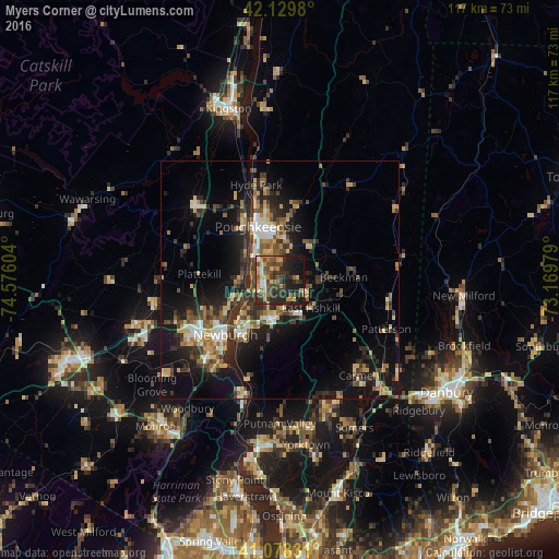
Analysis of Myers Corner night lights 2016
Square area 10x10 km:
 3.25%
3.25%90-99
2.44%80-89
7.47%70-79
7.95%60-69
7.31%50-59
6.98%40-49
11.04%30-39
15.1%20-29
17.21%10-19
20.62%0-9
0.65%Square area 50x50 km:
1.49%90-99
1.86%80-89
2.44%70-79
2.3%60-69
2.43%50-59
2.52%40-49
3.18%30-39
4.03%20-29
6.41%10-19
12.62%0-9
60.72%Clear (daylight) street map image can be seen on geolist.org.
Map coordinates:
42° 7' 47.3" North, 74° 34' 33.7" West
41° 36' 22.3" North, 73° 52' 22.5" West
41° 4' 41.9" North, 73° 10' 11.2" West
Some cities around Myers Corner sort by population:
• Poughkeepsie
11.2 km =7 mi,  339°
339°
• Newburgh
16.2 km =10.1 mi,  225°
225°
• Beacon
13.8 km =8.6 mi,  215°
215°
• New Windsor
19.1 km =11.9 mi, 221°
• Orange Lake
20.1 km =12.5 mi,  248°
248°
• Highland
14.7 km =9.1 mi,  330°
330°
• Wappingers Falls
3.3 km =2.1 mi, 251°
• Fairview
13.6 km =8.5 mi, 343°
5128238 (p: 6,790)
Sources (retrieved 2019-11-25):
» Earth at Night: Flat Maps 2012, 2016