Carmel Hamlet night lights from space
Night Light of Carmel Hamlet (New York) from space (United States) Src. Average luminocity for 10x10km area is 22.2024% and for 50x50km: 20.143%.
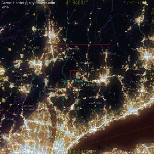
Analysis of Carmel Hamlet night lights 2016
Square area 10x10 km:
 0%
0%90-99
1.7%80-89
3.4%70-79
4.42%60-69
3.23%50-59
2.38%40-49
2.55%30-39
5.27%20-29
6.97%10-19
39.97%0-9
30.1%Square area 50x50 km:
1.28%90-99
1.98%80-89
2.87%70-79
2.65%60-69
2.54%50-59
2.71%40-49
3.64%30-39
4.52%20-29
8.53%10-19
19.82%0-9
49.46%Clear (daylight) street map image can be seen on geolist.org.
Map coordinates:
41° 56' 24" North, 74° 23' 18.1" West
41° 24' 53.5" North, 73° 41' 6.9" West
40° 53' 7.5" North, 72° 58' 55.6" West
Some cities around Carmel Hamlet sort by population:
• Danbury
19.4 km =12.1 mi,  96°
96°
• Jefferson Valley-Yorktown
14.5 km =9 mi,  221°
221°
• New Fairfield
17.6 km =10.9 mi,  70°
70°
• Mahopac
6.2 km =3.9 mi, 220°
• Lake Carmel
5.3 km =3.3 mi,  12°
12°
• Ridgefield
21.5 km =13.4 mi,  133°
133°
• West Point
22.7 km =14.1 mi,  263°
263°
• Lake Mohegan
17.2 km =10.7 mi,  231°
231°
7258078 (p: 6,817)
Sources (retrieved 2019-11-25):
» Earth at Night: Flat Maps 2012, 2016