Kerrville night lights from space
Night Light of Kerrville (Texas) from space (United States) Src. Average luminocity for 10x10km area is 36.3674% and for 50x50km: 2.659%.
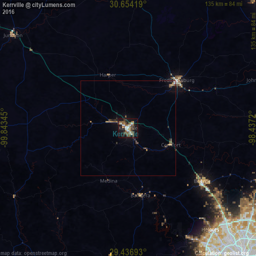
Analysis of Kerrville night lights 2016
Square area 10x10 km:
 5.3%
5.3%90-99
5.49%80-89
0.95%70-79
3.79%60-69
4.73%50-59
11.36%40-49
8.52%30-39
4.92%20-29
5.87%10-19
36.17%0-9
12.88%Square area 50x50 km:
0.22%90-99
0.26%80-89
0.18%70-79
0.31%60-69
0.29%50-59
0.74%40-49
0.58%30-39
0.43%20-29
0.46%10-19
2.17%0-9
94.35%Clear (daylight) street map image can be seen on geolist.org.
Map coordinates:
30° 39' 15.1" North, 99° 50' 36.4" West
30° 2' 50.7" North, 99° 8' 25.2" West
29° 26' 12.9" North, 98° 26' 13.9" West
Some cities around Kerrville sort by population:
• Boerne
48.4 km =30.1 mi,  125°
125°
• Timberwood Park
74.3 km =46.2 mi,  120°
120°
• Leon Valley
79.4 km =49.3 mi,  140°
140°
• Fredericksburg
36.2 km =22.5 mi,  45°
45°
• Hondo
77.8 km =48.3 mi,  180°
180°
• Helotes
67.9 km =42.2 mi, 140°
• Fair Oaks Ranch
58.5 km =36.4 mi, 124°
• Lakehills
52.8 km =32.8 mi,  158°
158°
4703078 (p: 23,136)
Sources (retrieved 2019-11-25):
» Earth at Night: Flat Maps 2012, 2016