Joshua Tree night lights from space
Night Light of Joshua Tree (California) from space (United States) Src. Average luminocity for 10x10km area is 4.9432% and for 50x50km: 4.075%.
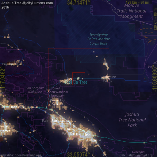
Analysis of Joshua Tree night lights 2016
Square area 10x10 km:
 0%
0%90-99
0%80-89
0%70-79
0%60-69
3.66%50-59
1.83%40-49
0%30-39
0.73%20-29
0%10-19
0%0-9
93.77%Square area 50x50 km:
0.12%90-99
0.21%80-89
0.1%70-79
0.21%60-69
1.82%50-59
1.24%40-49
0.75%30-39
0.79%20-29
0.37%10-19
2.21%0-9
92.19%Clear (daylight) street map image can be seen on geolist.org.
Map coordinates:
34° 42' 53" North, 117° 0' 58.3" West
34° 8' 5" North, 116° 18' 47.1" West
33° 33' 2.7" North, 115° 36' 35.8" West
Some cities around Joshua Tree sort by population:
• Cathedral City
41.9 km =26 mi,  199°
199°
• Palm Springs
40.1 km =24.9 mi,  212°
212°
• Desert Hot Springs
26 km =16.2 mi,  222°
222°
• Twentynine Palms
23.8 km =14.8 mi,  89°
89°
• Yucca Valley
11.2 km =7 mi,  258°
258°
• Thousand Palms
35.7 km =22.2 mi,  191°
191°
• Garnet
33.6 km =20.9 mi, 219°
• Bermuda Dunes
43.6 km =27.1 mi,  177°
177°
5361298 (p: 7,414)
Sources (retrieved 2019-11-25):
» Earth at Night: Flat Maps 2012, 2016