Palm Springs night lights from space
Night Light of Palm Springs (California) from space (United States) Src. Average luminocity for 10x10km area is 53.4633% and for 50x50km: 15.3249%.
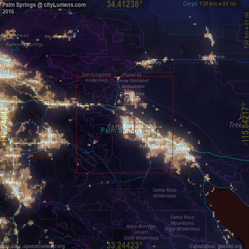

Analysis of Palm Springs night lights 2016
Square area 10x10 km:
 13.11%
90-99
11.19%80-89
9.09%70-79
3.85%60-69
8.22%50-59
7.69%40-49
5.24%30-39
4.9%20-29
9.44%10-19
19.41%0-9
7.87%Square area 50x50 km:
1.9%90-99
2.29%80-89
1.76%70-79
1.93%60-69
4.07%50-59
2.72%40-49
1.77%30-39
1.93%20-29
3.73%10-19
7.98%0-9
69.92%Clear (daylight) street map image can be seen on geolist.org.
Map coordinates:
34° 24' 44.6" North, 117° 14' 54.3" West
33° 49' 49.1" North, 116° 32' 43" West
33° 14' 39.2" North, 115° 50' 31.8" West
Some cities around Palm Springs sort by population:
• Cathedral City
9.3 km =5.8 mi,  127°
127°
• La Quinta
28.6 km =17.8 mi, 130°
• Desert Hot Springs
15.1 km =9.4 mi,  14°
14°
• Rancho Mirage
15.9 km =9.9 mi, 129°
• Thousand Palms
14.4 km =8.9 mi,  94°
94°
• Garnet
8 km =5 mi,  359°
359°
• Bermuda Dunes
25.6 km =15.9 mi,  112°
112°
• Indian Wells
22.5 km =14 mi,  123°
123°
5380668 (p: 47,371)
Sources (retrieved 2019-11-25):
» Earth at Night: Flat Maps 2012, 2016